Ex-aug-hausting, in a good way

by: August 29th, 2010 comments: 3

August has been awesome. Busy and intense, in a transitional sort of way. We’ve been putting a wrap on mapping in Kibera (for now) and planning the first replication to Mathare. And along the way, getting out, doing stuff, meeting people. Here’s a shotgun of August.

Getting Out

TedX

Regynnah has been speaking on Map Kibera, and Sande on Voice of Kibera, and TedX tours four informal settlements throughout Nairobi. It’s a great idea to make connections between these areas, they have more in common than not, and can learn and build with each other.

Maker Faire Africa

IMG_2323

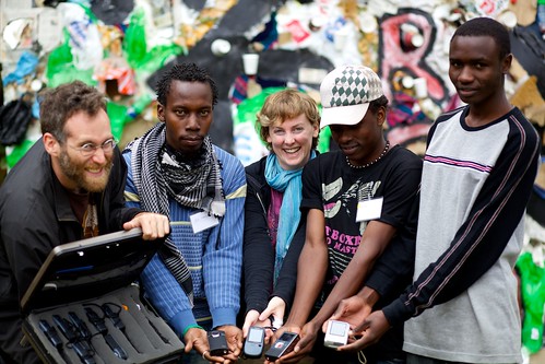
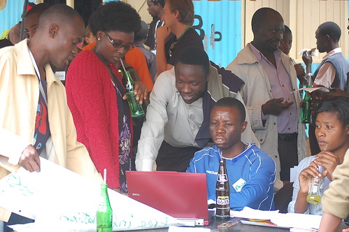
Kibera News Network came out in force to contribute to the fun house that is Maker Faire Africa. Gratifying to see lots of existing knowledge and interest in Map Kibera and OpenStreetMap.

Mukuru

Primoz helped Millicent and Kevin lead a 2 day mapping party (plus 2 day follow up) with mappers in Mukuru. These guys have been working with Partnership for an HIV-free Generation and Emory University, and had previously done some paper based mapping. Super enthusiastic group, opens the door to more work there.

Getting Recognized

Youth Fund

Map Kibera was awarded a grant by the UN Habitat Youth Fund! The group now has support to directly and independently replicate in another Nairobi informal settlement, sometime next year. We’ll have more to say on this later on.

Ars Electronica

And we were awarded Distinction by the Ars Electronica Festival, in Digital Communities category! Should be even more wild than Maker Faire.

Robert Chambers and Mark Hamnolan

Kibera News Network has been going strong, producing high quality reporting, during the Referendum and otherwise. This weekend, they had a visit from Professor Robert Chambers, a pioneer in participatory approaches to development. And Mark Hamnolan is here, working with KNN to interview Kiberians about crisis for a Red Cross project, and generally share some skills.

Wrapping Up

Water/Sanitation is wrap

Soweto beautyfire self-help group

We finally finished editing on the final theme of “phase 2” of Map Kibera, Water and Sanitation. We held a community map drawing meeting at the offices of KWAHO, attended by many professionals from the watsan network of Kibera. The discussion was extremely interesting, and opened up many possibilities for application of maps and other tools for their work.

We’ll continue to engage in Kibera, to figure out how the map can live and benefit this and other core issues.

Put a bow on it

With help from Meghana, we’re redesigning the Map Kibera site to present everything we’ve learned over the past 6 months. Luckily we’re in good hands.

On the mapping side itself, Eric Brelsford has been rationalizing the crazy tags that evolved out of mapping the kind of place completely new to OpenStreetMap. He’s looking at improving the rendering for each theme, in seperate layers, and may be getting some help from a certain large company that’s recently taken a big interest in OSM.

On the printing side, we’re nearly through the design process for the posters and atlas. Primoz and Emma have been working hard translating the mass of digital information to paper. These will be printed up in the hundreds and distributed to organizations, schools, etc throughout Kibera.

Apps4Africa

I’m mentoring two projects in Apps4Africa. I’ll have more to say on those soon.

Making Plans

Mathare, Rebel Film Board, PLAN CLTS

In Mathare, we’ve been greeted with lots of enthusiasm when presenting to the Rebel Film Board, and the Community Total Led Sanitation network. There’s many more groups and people who are welcoming us to Mathare. The ground work is being set for our next steps there. PLAN International is also coming on board to support.

Strategic Thinking

In the rest of our free time, we’ve been taking a look to the long term. How do we carefully build on the successes in Kibera, and bring the benefit of these tools to new communities? Will be interesting for sure.

Mapping Flood Damage in Kibera

by: August 28th, 2010 comments: 0

A couple of months ago, a series of storms caused havoc in Kibera. Our team was taking a much needed vacation at the Kenyan coast, and while we were sipping gin and tonic and absorbing the sun and endless blue sky, the people of Kibera were battling against rather less favorable weather up on the high plain of Nairobi. As our team returned to Nairobi, we received a call from the United Nations OCHA Kenya: “We heard there was some flooding in Kibera and Mathare, and since you have a presence there, we’d like you to go and check it out.” We had no idea. So I called one of our mappers, Hasan, and he confirmed the whole thing.

The area where Kibera is located is very hilly. It’s made up of a group of drainage areas intersected by 5 streams, which eventually end up in Nairobi dam. During heavy rains the runoff water travels over the surface of the slum and ends up in the streams. These become overflowing, raging currents, grinding everything in their way, washing away houses, paths, garbage and people.

Hasan and I went to check out the damage and collect information. I was overwhelmed. This was a major incident which should trigger massive coverage, but went almost unnoticed, even by us. There were more than 50 houses severely damaged, displacing the inhabitants. One school was completely swept away. Walking calmly, I didn’t even notice anything in particular, until Hasan suddenly pointed out that I was standing where only days ago a school had been. Not even the foundations were visible anymore.

Damaged objects down the stream

We started collecting data points of all the damaged objects, which were mostly located on the banks of the slum’s streams. In a testimony to Kibera’s obstinate spirit, many of the damaged objects were already being repaired and rebuilt. The paths inside the slum, too, were being fixed by groups of young volunteers. People organized themselves without waiting for any kind of help or intervention from the outside. Had it not been for Hasan pointing out the repair activity among the usual busy scene of Kibera, I may not even have noticed this almost organic reaction of the slum to its wounds.

We decided that we’re not going to take the position of every damaged and rebuilt object across the slum, because it would take too much time, and we had a tight deadline. We focused on the primary damage along the streams, since we could still upgrade the information if needed, depending on the feedback. In order to collect the information as fast as possible, Hasan organized his friends around Kibera to go and look around their communities and try to figure out the extent of the damage inflicted by nature’s fury. Within two days we had an in-depth map of the extent of the damage for OCHA.

This project showed me couple of things:

-The importance of having local people on the ground, trained in data collection, which can be activated at any time. Because of this, the time in which information was available to OCHA was shortened to only a couple of days.

-The information on repaired objects could be used to make a case for compensations.

-Visibility matters: Even major events with many deaths and widespread destruction can go mostly unnoticed by the outside world when they affect marginalized places like Kibera. Recording information on damage, be it on a map or through local newscasts and papers, is the crucial first step to mobilize help in support of the local community.

Voice of Kibera, Ushahidi 2.0, and Our Wishlist

by: August 22nd, 2010 comments: 3

With the much appreciated help of crowd-sorcerer Henry Addo, we have upgraded Voice of Kibera to Ushahidi 2.0, and the plugin system.

The first plugin we installed immediately was the mobile plugin, which sure, gave us iphone and ipad support but what really excited us was support for any phone, really any phone, with any kind of internet access, via a web browser. In Kenya, mobile internet is booming and it is not uncommon for Kibera people to have internet enabled phones, mostly accessing Facebook. The cheapest internet enabled phone on the market is only 2000 KSH ($25). Phones and data are only going to get cheaper. For many people, the phone will be the first real chance to access the internet, and I reckon WAP is going to really take off. 10 years ago in the EU, WAP was over-hyped and crashed because people were used to a full internet experience, and didn’t really get interested in mobile internet until the iPhone. Here in Kenya, WAP is the right technology, right now. I’m incredibly excited to see what happens now that Voice of Kibera is available on the phone.

IMG_6763

An Alert on Alerts

With 2.0 finally out of the way, I had a chance to examine our bugs and features against what’s in 2.0. One long standing issue for VoK, and I’m told other instances, were that Alerts didn’t work correctly. Sometimes they didn’t get sent out at all, or got sent out in huge numbers, almost spamming subscribers (this happened with Uchaguzi, I’m told). I had never investigated or confirmed this, but after a quick test yesterday with VoK, yes, alerts weren’t working!

I examined the code and the database, and discovered the problem. Reports are marked for alerting when approved via “admin/reports/index”, but not via “admin/reports/edit”. This means that if someone marks a report as approved while applying or reviewing location and category, it’s never sent out for alerting. At least with Voice of Kibera, this is the common usage pattern, and I suspect the majority of instances … the same person who creates and geocodes the report, approves it. The approver is often going to check out the map, rather than just read a summary. It’s only in specific circumstances that index would be used on Ushahidi instances, and I can’t say how often that the report listing would be used. This inconsistency made it a troublesome bug to figure out.

Anyhow, I submitted a bug on this, and David Kobia quickly submitted this fix. I was a little concerned that such a core feature had a major bug, but very glad that Ushahidi quickly responded to my report.

If you’ve noticed any problem with Alerts in your Ushahidi instance, I suggest at least applying David’s fix, if not upgrading to the latest codebase completely.

SMS Wishlist

Along with WAP, we see SMS Alerts as a major way Voice of Kibera will be accessible in Kibera. We’ve examined how things work, and have come up with a number of improvements.

  • Should be able to sign up for Alerts to specific category, rather than everything. I believe the Haiti instance had this, but that hasn’t been integrating to 2.0
  • Should be able to sign up for alerts via SMS. For example, someone interested in sporting events could text in “Kibera subscribe sports” and be signed up. That will text them back information on how to unsubscribe via SMS, etc.
  • Admins should be able to toggle whether a specific message is sent out for alerts. Looking at the code around the bug above, I see this would be straightforward.
  • Admins should be able to mark a report for sending only via SMS, and not on the site. These could be special communications, or take the form of a daily/weekly digest of information.
  • Finally, it would be helpful to assign a name to SMS reporters and subscribers. Reports should be linked to messages that come in via SMS, so that you can see the original message and reporter when approving.

Geo and Other Stuff

Naturally being a mapping guy, I have lots of ideas! One thing that happened in Uchaguzi, and in Haiti and Chile, was a choice of base map layers, so that both OpenStreetMap and Goog were available. These were done by hacking in a little OpenLayers javascript. It would actually be pretty simple to offer a choice of several base map layers in core Ushahidi. Also helpful would be a little design work to make base map choice more obvious.

That could lead to more custom base map layers. During Uchaguzi, there was an unfulfilled need to overlay polling place districts on the map. Since that’s a fairly large KML, a more efficient method on the browser side would be to build up semi-transparent tiles.

Another place to look is geocoding. Currently only Google geocoding is offered, while there are other good, and free, services like Nominatim (based on OSM data) and Geonames. Which geocoder is in use should be somewhat invisible to the reporting interface, and done in an efficient cascade. Also, need to present choices of results to user, rather than just the first.

There may be circumstances where you want to build your own custom geocoder. Again, Uchaguzi could have benefited from geocoding on polling place locations; that database was available, but not with a license shareable with OpenStreetMap (it’s a looong story). What could be done is build up a geocoder using the open source geocommons geocoder, and integrate it with Ushahidi via its RESTful interface.

Anyhow, just a few ideas, which we’ll be processing into specific bug reports and feature requests, and yes, finding time to work on … it’s open source after all!