The schools mapping of the Kangemi slum and associated surroundings was a very successful exercise, and provided much-needed information for everyone from Kangemi’s residents and parents to policy advisers and education experts to governmental education officials.The project brought together youth residents of Kangemi with Map Kibera mappers, who, working closely with local school leaders and advocates for informal schools, mapped nearly 300 schools. These now appear on Map Kibera’s Open Schools Kenya school database. The mapping exercise, possible thanks to the support of Indigo Trust, has brought visibility to these schools, and increased both information and knowledge about the number and kind of schools in Kangemi. It has also equipped schools and activists with a key resource in advocating for improvements to and recognition of these schools.
Just like in Kibera, before the project began, Map Kibera conducted a survey with parents, teachers and government officials to try and understand the information gap in regards to education. Parents, for example, were interested in the distance of a school from their home, how much a school charges, and the ratio of teachers to students before selection a school for their children. Other data points that were collected included the number of students, availability of toilet, school building materials, electricity availability, number of teachers, and many more.
Map Kibera also talked to teachers and school leaders, and met with a number of important figures in Kangemi education. Particularly supportive throughout the exercise was Kangemi’s Alternative Provision of Basic Education and Training (APBET) coordinator, Evans Onchiri. Evans is a tireless advocate and organizer on behalf of the schools, and he particularly welcomed the addition of detailed data and maps to better support APBET schools (APBET is what the schools are now called which were previously known as “informal” or “non-formal”). Map Kibera found that although there is a government policy to recognize these schools — which would allow them to access more resources, have some oversight in place, and be part of the provision of free basic education guaranteed by law to all children — the process of registering under the policy is not clear and has been stalled over several years. Having a better idea of the number of students served and locations of these schools is essential to pushing forward on this policy. The Sub-County Education Director, Phillip Chirchir, and the area Member of Parliament (MP), Tim Wanyonyi also indicated to Map Kibera that they needed a more comprehensive understanding of the schools in their area.
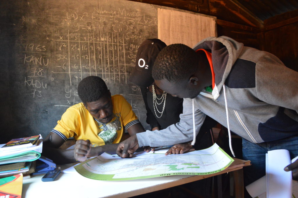
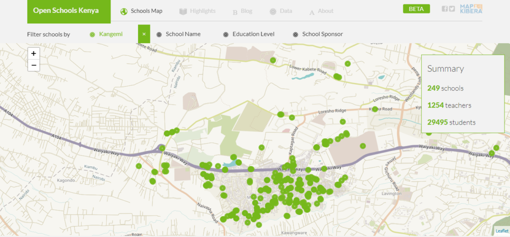
The schools mapping exercise covered both the schools already on local leaders’ lists, and also unknown schools found directly in the field. From the initial main focus areas of Kangemi, which included Kangemi ward and Mountain View ward, the schools mapping exercise was expanded to other slum areas, following the request of the Sub-County Education Director and the area Member of Parliament. The additional mapped areas are the following: Kibagare slum, Deep Sea slum, and Githogoro slum. All the mapped areas fall into the Westlands Sub-County. The total number of the mapped schools is 282, out of which only 19 are public schools, including pre-primary, primary and secondary levels. Therefore, the majority of schools (263) are APBET schools.
A few outcomes:
Seven youth have been trained in Kangemi on how to collect data using the OpenDataKit app, how to edit maps using JOSM software, and how to upload data onto OpenStreetMap. The youth reported a general satisfaction about the additional skills learned. After the completion of their work, the youth mappers reported raised awareness and general knowledge about their own community. Moreover, the new team of trained mappers in Kangemi could be further involved in updating schools’ information and in other related local developments.
The website Open Schools Kenya has been made mobile-friendly so that it can be easily viewed and used on a smartphone. Previously, due to the difficulty navigating a map on a small screen, the site was best viewed on a laptop. Thanks to feedback from users at schools, we prioritized making sure that they can also navigate the site using their phone’s mobile browser. This makes the data much easier to access. Additionally, we worked on the submission form for data corrections, making it more user-friendly and better suited to the needs of schools to submit changes.
The schools and teachers have been very happy about the project. In the first phase, they reported interest in knowing the location of their own school and of the other schools in the area, in particular, to better know the number of pupils, the facilities and the services provided by the other schools. After the mapping exercise was completed and the schools received the printed map, they reported surprise at being able to see the outcomes of the project. In fact, during past experiences, many researchers went in the area collecting data without going back afterward for community restitution and feedback. Moreover, they reported general excitement for being able to locate their own school on the map and to be able to display the printed map in their office for multiple purposes. The schools also highlighted the importance of the online school page. Having their own specific page on OSK, they are now able to easily update the information, advertise and fundraise for their school, and also help engage parents in the community in decision-making about where to send their sons and daughters to school and increase the quality of their education.
Key local education officials were particularly pleased with the outcomes of the mapping exercise. Both Ms. Esther Kimani, the Sub County Quality Assurance Officer, and Mr. Phillip Chirchir, the Sub County Director of Education, highlighted the importance of being able to locate the schools, especially APBET schools, and to have the head teacher’s contact for each school on the OSK website. They are now able to better reach out to the schools and advise the Ministry of Education about their needs.
Map Kibera is now collaborating with education specialists from local organizations Each Rights and African Population and Health Research Centre (APHRC) to include the data and findings of the mapping in their advocacy and policy advising. With their assistance, already Map Kibera has presented the schools’ map to the National Council for Nomadic Education (NACONEK), which oversees APBET country-wide, at a joint meeting discussing schools information and potential mapping of all the APBET schools in Nairobi. Map Kibera has also been working with the Kangemi Resource Centre, a local CBO, to establish a workspace for the Kangemi mappers and to develop joint plans for updating the schools’ data regularly. All three of these key partners also presented at the launch event, which allowed them to connect with the various Kangemi school leaders and share some of their advocacy work.
The schools mapping in Kangemi and beyond led to an increased awareness of existing schools and resources within the community itself. As a teacher from a school in Githogoro slum stated, the schools in these marginalized areas are usually left out from development in Westlands. Both the map and the website are therefore crucial to make visible and clear their presence in order to assure their inclusion into the public education system and the overall education policymaking and planning.
When around 15 police trucks came to Kibera a few weeks ago to witness and protect the demolition of schools along the railway line, there was shock and tension as Spurgeons school was targeted. But before the bulldozer could reach the permanent building, the community members turned up in large numbers to stop the demolition, saying that the school belonged to them. They claimed that the school has been helping their needy children and they could not sit back and watch it go down.
“Bars are operating you can hear loud music, but schools that are helping the children are being demolished, what’s the government doing?â€
47 schools, along with other structures including churches are expected to be demolished during the project, but attention to St. Juliet and Spurgeon forced a halt on the process for a while.
Kenya Railways decided several years ago to expand the railway buffer and reclaim the land, citing safety and interference with train passage. In 2010 they made their most recent enumeration of the residents and businesses along the track targeted for demolition, but residents say that these are already outdated. While residents have been promised new housing, they do not appear to have made concessions for the schools operating in the buffer area, other than saying that the schools be shut down and students enrolled at nearby government schools.
Recently, a petition by a section of the Project Affected Persons (PAPs) had been filed in court and a ruling was made, stating:
1. The petitioner’s petition fails and is dismissed
2. The Respondent’s cross-petition succeeds and it is hereby ordered that the recent illegal occupiers of the Railway Reserve whose names do not appear in the list of the Project Affected Persons do move out of the Railway Reserve and allow the Corporation to proceed with the Resettlement plan.
Their evictions however will have to take into account the following factors:
That at the time of eviction, neutral observers should be allowed to access to the suit properties to ensure compliance with international human rights principles.
That there must be a mandatory presence of Government officials and security officers.
That there must be compliance with the right to human dignity, life and security of the evictees.
That the evictions must not take place at night, in bad weather, during festivals or holidays, prior to any elections, during or just prior to school exams and in fact preferably at the end of the school term or holidays.
That no one is subjected to indiscriminate attacks.
The PAPs had demanded in their petition that a review of the enumeration be done since a lot of things had changed since 2010 when the last enumeration was done, but the Kenya Railways refused saying that it was going to be a waste of money and time and would only add more complications to the plan.
Community Meeting with Langata Youth Network
Recently, Langata Youths Network organized a forum to bring together all the affected schools and churches along the Railway to look at the way forward. They resolved that the people concerned with the demolitions be engaged further to make them understand why dialogue was still important in every stage and step they make. They also said that they will try to respect the court ruling by all means, but they wanted to understand who made the decision that some schools to remain while others to be demolished. The group then formed a committee to help follow up with all the relevant offices.
There has been a lot of silence since the demolition of the few schools happened, until recently when we saw a notice posted asking the PAPs to go for a vetting process. This sounded to me like a review that they had all along been crying for only called by a different name or word. It says that the vetting and complaint lodges will continue and a final list of the PAPs would be published publicly.
Meanwhile the schools already demolished are proceeding with learning as best they can. St Juliet returned some of its class roofs, while Spurgeon is squeezing inside their permanent building that the community members had narrowly rescued in the presence of heavily armed police.
According to the Relocation Action Plan (RAP) Document the Schools along the railway should close down and send their students to the few public schools in Kibra, but the Schools wondered how they would do it since the RAP did not give a proper guideline on who is responsible for taking the students to those particular public schools, and were not sure whether they would be admitted.
This piece was a collaborative report by Map Kibera’s team as part of the Open Schools Kenya project. Reported by Joshua Ogure, with map by Zacharia Wambua, school locations by Lucy Fondo and Douglas Namale, and reporting from Steve Banner and Jacob Ouma.
“If you play your part, and you play it to your level best, then your gift will surely open more doors for you,” observed one Fred Ogutu, Hope Academy director.
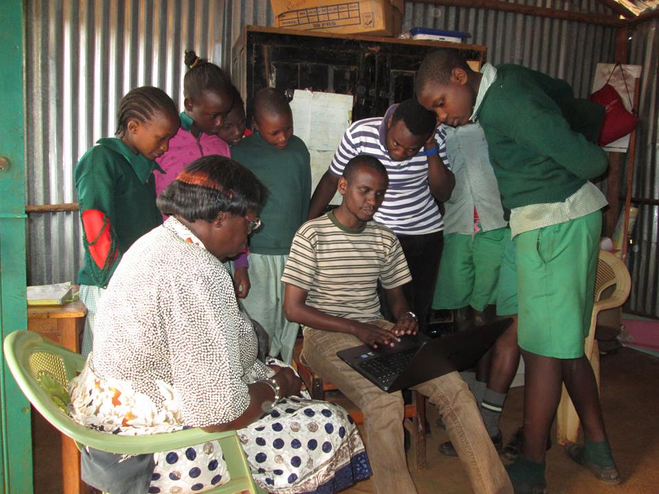
St. Stephene school students and teachers view their school profile online.
We started our distribution on the Langata constituency part of Kibera, that is Raila village. Kibera is spread over two constituencies, Kibra and Langata constituencies, with Kibra having the biggest portion.
All the schools in Raila village had a very positive approach to the map, and the site. They very much welcomed it despite the fact that some of them were a bit reluctant to give out information during the previous data collection.
Map Kibera member Zack Wambua shares the map with Maono Secondary School
Joy and excitement may have sent the Maono Secondary School head teacher the religious lecturer way, telling us that these are the end times and why everyone needs to repent and get ready to receive Christ when he comes. He did that for a few minutes then went ahead to tell us how the school will now use the Open Schools website as their official website.
At St. Stephene school, the head teacher even offered us a job, to help her draft the 2015 school activity plan that she intended to send to her donors together with a link to their page in the Open Schools Kenya website.
Hope Academy school director, Mr. Fred Ogutu, having featured in almost all our previous Project phases including the pre-project survey, was now well informed about what we are doing and congratulated us a lot on the good work done so far. He had a lengthy talk with us telling us that Kibera is a slum that has so much been misrepresented, with a lot of false data out there, he cited an example of the current Government-driven National Youth Service project which has, to use his own words, been blown out of proportion yet none of the clinics and toilets that the government seems to boast about are functional.
He observed that our data is one of the few genuine ones and wondered if the work we do also translate to helping us personally besides fighting to change our community. ‘Are you able to put food on the table and pay your rents?’ he posed a question.
In other villages, that is Katwekera, Kisumu Ndogo, Kambi Muru and Makina, the reception was equally good. We did manage to take fresh photos for FPFK Gatwekera school .
At Joseph Kangethe School, which is one of the two public schools that my colleague Zack and I were assigned to, had a very nice view of the map, The deputy head teacher asked us to come up with forums to educate parents in Kibera on the need to take their children to public schools. She said, contrary to what most parents expressed in the pre-survey, that public schools are being deserted and parents are flooding the non-government schools leaving the government schools with empty classes. “Public schools that had four streams per class have now reduced to three streams. We’ve been forced to turn the extra classrooms to stores because there are no children.”
She also added that learning in public schools is far much better than private schools where children are ‘just drilled and not taught’.
‘What is the government doing about that? And what are you as Map Kibera, in your education project doing about that?’ were her last questions.
Stephene ‘Steve Banner’ Oduor
Map Kibera Trust
Where Am I?
You are currently browsing entries tagged with OpenSchoolsKenya at
Map Kibera.