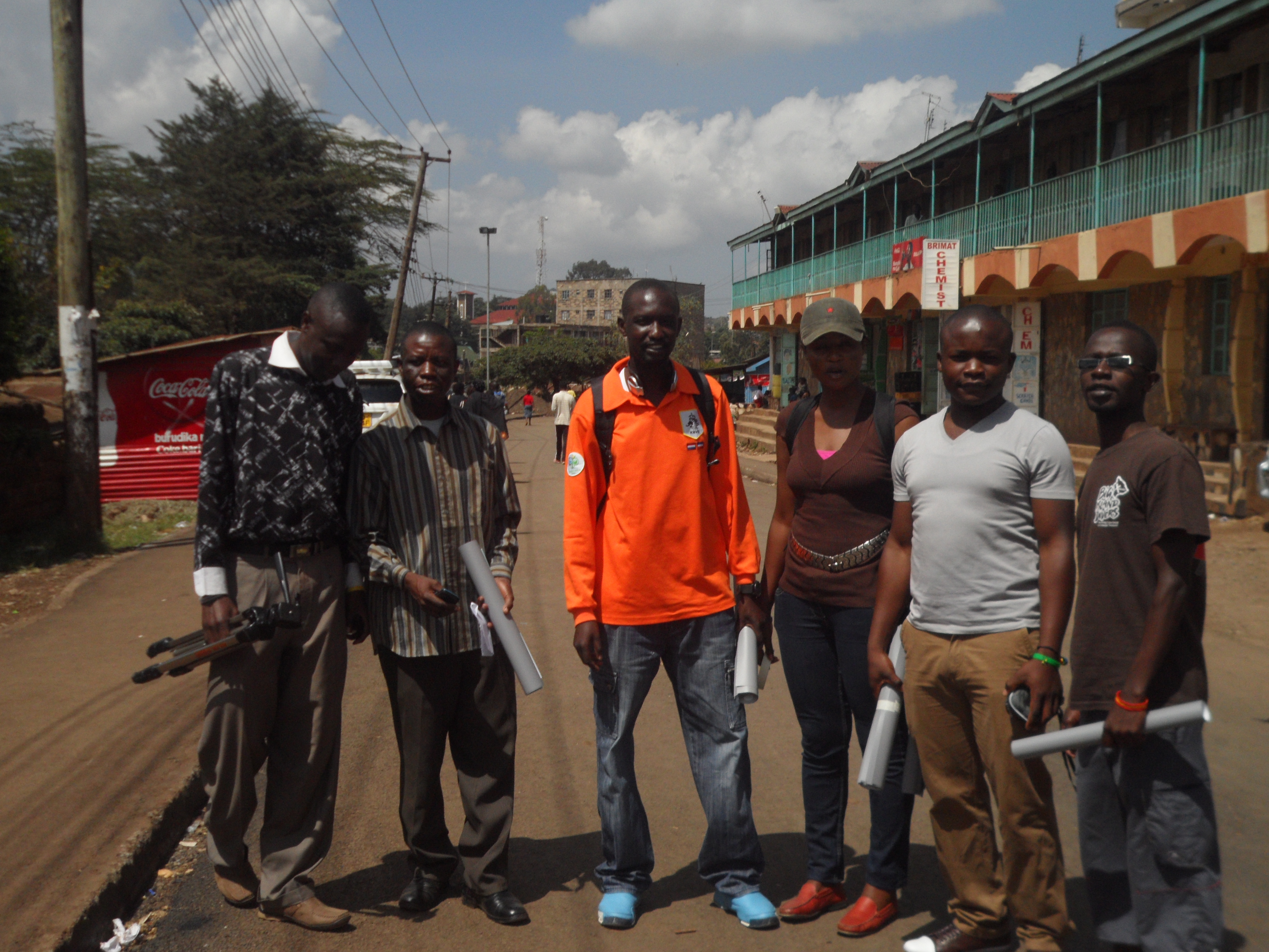
Having been the first organization to put the entire Kibera slums on the world map, Map Kibera Trust; an organization that seeks to be a hub where access to open information contributes to positive community transformation was on the road again to ensure that the maps that were produced reached the community which in-turn would put them to use.
To achieve this, the program coordinators met for the preparation of distributing the maps; there intention of meeting was to bring the attention of the three programs on how they will be working together towards achieving the objective of the exercise and to come up with relevant locations for maps distribution. It was there that they agreed that members from the 3 programs; Mapping, Voice of Kibera and Kibera News Network were to go to the field to distribute the maps which had been developed based on themes. Maps on Education, Security and Health are the themes that were distributed.
The aim of the exercise was to give back to the community through the high quality printed maps that contain the informational that came from them during the first phase of the mapping exercise.
Villages covered.
For the 2 days that we were in the field, we were able to cover all the 13 villages; Gatwikera, Raila, Olympic, Soweto west&east, Kianda, Kambi muru, Kisumu ndogo, Lindi, Mashimoni, Makina, Silanga, and Laini Saba.  Â
Positive Feedback From the Field.
As we visited different places, we collected feedback from the people we found so that we could ascertain how the maps will be put to good used.
The local administration appreciated our work and accepted to be interviewed i.e. Sarang’ombe and Laina Saba ward chiefs.
Most of the institutions accepted to use the map for positive transfiguration most of the institution wanted more than one map so they can use it for informational purposes as well as Education especially the Schools we visited.
We even had a chance to meet with D.O 1 (District Commissioner) who had a compliment for us saying that our map was outstanding compared to the one they had before.
For those who were not able to access our maps online were able to access them on hard-copy something that was important for us since it was now realized.
We ensured equal distribution of maps in at least all villages in Kibera.
Some of the Challenges.
Though most of the places we went to were very receptive, we experienced some hostility in a few areas where we were thought to be a different group out to just take advantage of the situations in Kibera by walking around to talk to people as we take photos to go and sell. After a few minutes of sharing our intentions with them, they understood us and we gave out the maps, something they congratulated us for showing a good example to organizations by sharing the findings of the work done with the community. We also found some schools that were to get maps already closed for holiday which means we will have to give them the maps when they resume school.
Conclusion.
In general, the exercise was a success only for the schools that had already closed. Going forward, we need to print big and more visible maps a suggestion that came from one of the places we visited.
We hope that the maps distributed will not only be put to good use but also help Map Kibera Trust bond more with the community so that even as we get ready to cover the vents before, during and after the elections, we can work together to achieve optimum results and that Kibera and the other slums we are currently working with (Mathare and Mukuru) will never be the same again.
and if you’re curious, a little more detailed Report
Throughout October and November 2011, Plan Kwale worked through Map Kibera Trust with Primoz Kovacic and I, along with 4 young people from Kibera (Zack Wambua and Maureen Omino) and Mathare (Jeff Mohammed and Javin Ochieng), to conduct digital mapping exercises to support ongoing youth-led development processes in Kwale county. One of the important lessons learned through the Trust’s work in Kibera and Mathare is that the stories behind the mapping work are important for understanding the processes that contribute to a situation as represented on a map. To tell these stories and to complement the data collection and mapping work done by the youth in Kwale, the Map Kibera Trust team worked with the Kwale youth to set up platforms to share this information nationally and internationally. Sharing the important work being done in Kwale will hopefully bring greater visibility to the issues which may in the longer term lead to greater impact.
Sharing stories of local governance
To support their work on social accountability, the Kwale Youth and Governance Consortium mapped over 100 publicly and privately funded community-based projects. The projects were supported by the Constituency Development Fund (CDF), Local Area Development Fund (LATF), NGOs and private donors. As one channel of sharing this information, the Consortium set up a blog called Nuru ya Kwale (Light of Kwale). According to KYGC the blog “features and addresses issues concerning promotion of demystified participatory community involvement in the governance processes towards sustainable development. We therefore expect interactivity on issues accruing around social accountability.†This involves sharing evidence about various projects and stories from the community.
One example is the documentation of the Jorori Water project in Kwale; through the mapping work, the Governance team collected details of the constituency development fund (CDF) project. The funding allocated to upgrade the water supply for the community was 6,182,960 ksh (approximately 73,000.00 USD). From their research the KYGC identified that the Kenya Open Data site reported that the full funding amount has been spent. A field visit to the site however revealed that project was incomplete and the community is still without a stable water supply, despite the fact that the funding has been “spent.â€
Read more about the questions the team raised in terms of the governance of CDF projects, including the detailed the project implementation process and some reflections on why the project stalled. This is information on community experiences (tacit information) that is well-known in a localized context but has not been documented and shared widely. New media tools, a blog in this case, provide free (if you have access to a computer and the internet) platforms for sharing this information with national and international audiences.
Addressing violence against children and child protection
Another blog was set up by the Kwale Young Journalists. The Young Journalists, registered in 2009, have been working with Plan Kwale on various projects, including Violence against Children campaigns. The group has been working to set up a community radio station in Kwale to report on children’s issues. Thus far, their application for a community radio frequency has encountered several challenges – new media provides an interim solution and will allow the team to share their stories and network with partners on a national and internal stage.
The Kwale Young Journalists worked with Jeff Mohammed, a young award-winning filmmaker from Mathare Valley. The YETAM project not only equips young people with skills, but through peer-learn establishes connections between young people working on community issues throughout Kenya. The programme also provides young people with life skills through experiential learning – Jeff reflects on his experience in Kwale and says:
“My knowledge didn’t come from books and lecturers it came from interest, determination and persistence to know about filmmaking and this is what I was seeing in these Kwale youths. They numbered 12 and they were me. They are all in their twenties and all looking very energetic, they had the same spirit as mine and it was like looking at a mirror. I had to do the best I could to make sure that they grasp whatever I taught.â€
Jeff worked with the Young Journalists on a short film called “the Enemy Within.†The film, shot with flip-cameras, tells the story of 12-year-old girl who is sold into indentured labour by her parents to earn money for her family. During the time she spends working, the young girl “falls prey of her employer (Mr.Mtie) who impregnates her when she is only 12 years old.†Jeff reflects that “early pregnancies are a norm in the rural Kwale area and what the young filmmakers wanted to do is to raise awareness to the people that its morally unacceptable to impregnate a very young girl, in Enemy Within the case didn’t go as far because the village chairman was bribed into silence and didn’t report the matter to higher authorities.†This is a common scenario in Kwale, and the young journalists plan to use the film in public screenings and debates as part of their advocacy work in the coming months.
Jeff and the Kwale Young Journalists shot the film in four days – they travelled to Penzamwenye, Kikoneni and also to Shimba Hills national park to shoot 7 scenes for the movie. Read more about Jeff’s reflections on working with the Kwale Young Journalists on his blog.
Sharing ecotourism resources
The Dzilaz ecotourism team – a group that encourages eco-cultural tourism in Samburu region of Kwale count – also integrated social media into their work. During the last week (November 8th-12th) the group set up a blog to market the community resources, services and products. They also plan to document eco-culture sites and the impact that eco-tourism can have on the community. As of November 10th, 2011 the Dzilaz team had already directed potential clients to their website and thus secured a booking through the information they had posted.
The importance of telling the stories behind the maps
One important component to mapping work is to tell the stories behind the map. The three groups in Kwale are working to build platforms to amplify their grassroots level work in order to share stories and lessons learned; the information documented on the various platforms will hopefully develop over time and contribute to a greater understanding of the processes at a local level – and where youth as young leaders can intervene to begin to change the dynamics of community development.
I believe that the reasons to map open drainage in the slums are well known and are obvious to most people. Everyone who’s ever been to the slums knows that open drainage presents a huge health hazard to the people living around it. In combination with poor or non-existent water and sanitation systems, open drainage presents a recipe for disaster which is always present and can erupt at any time and wreak havoc amongst the populations. If I quote a few experts on the dangers that open drainage poses:
“Potholes in the streets, pools of stagnant water, and waste gushing from bathrooms and kitchens provide breeding sites for malarial mosquitoes and other spreaders of disease.†(Nwaka, Geoffrey I. “The Urban informal Sector in Nigeriaâ€)
“Most slum households must fetch their water from a standpipe and deposit their waste in open drains. The rate of infection is high; therefore there is constant risk of epidemic.†(Gulis et. Al. “Health status of people of slums in Nairobi, Kenyaâ€)
“In slum areas, a minor flood is not just inconvenient. It is life-threatening. With open drains and overflowing latrines even a small flood means that children have to wade through raw sewage.†(Willem Alexander, HRH, Chair of UNSGAB. “World Water Day Op Edâ€)
In an article on the health status of people of slums in Nairobi, Kenya the authors conclude that: “Environmental conditions can have major influences on health status. Therefore, environmental improvements are important in the improvement of health status.†(Gulis et. Al. “Health status of people of slums in Nairobi, Kenyaâ€)
As my friend Simon, a long-time resident of Mathare and our Map Mathare Coordinator, put it on the Mathare Valley blog: “One does not need to be a scientist to know what would happen in case of disease outbreak. The improvement of proper water distribution and repairing the broken water pipes coupled with constructing good drainage system is the key to fighting common illness in the slums.â€
What I can add to all of this is that in order to improve or at least start improving living conditions, you need to first know and understand the situation on the ground. By mapping open drainage areas, our mappers are providing the first detailed geographical information about how open drainage is distributed throughout Kibera and Mathare, thus providing necessary information to anyone hoping to solve the problem.
This I believe answers the question of why and brings me to the next question: How?
Obviously open drainage creates “appalling living conditions,†but maybe not so obviously, it creates appalling mapping conditions too! Open drainage winds and curves between houses, often sinks below them, intersects, flows, stands, overflows, merges with the content of broken sewage lines (sewage lines burst and sewage comes above ground, mixing with the content of open drainage), and creates pools of standing water. Open drainage is the main collector of garbage: garbage in open drainage areas often clogs drainage systems, thus creating floods during rains. All of this mesh slowly flows downwards, usually towards rivers that pick it up and carry it further downstream, polluting the environment sometimes hundreds of kilometers away.
In order to understand the scale of the problem in Mathare and Kibera we went on an investigative – or, if I put it in army terms, reconnaissance – mission with our teams to see the problem first hand. Our participants surveyed the problem, and their input helped us to better understand what we’re up against. We walked through the slum evaluating different drainage lines and problems we faced in mapping them, Sebastien (our new volunteer) and I then facilitated the mappers to decide on which points of interest we should collect and in what order.
Investigating the problem
Findings from the field regarding open drainage include:
Open drainage has many sources and it forms for many reasons (resulting from topography and from human actions)
It comes in many forms regarding the content and structure (garbage, water, sewage, earth trench, concrete trench, etc.)
It has main channels with many tributaries
We came to realize that drainage systems in slums (Kibera, Mathare) basically work as micro river systems! This made us understand that it has to have an outlet, and both Kibera and Mathare have outlets in the form of rivers that run through them.
All of this helped us made our action plan:
All the drainage flows towards the rivers, so we started collecting data along the rivers.
The next step is to collect data for the main channels, which lie along the main paths.
After this, we focused on the smaller paths in the slum, collecting points of interest along the way. This includes the start and end points for “following†a drainage line, intersections of different lines, man-holes (along sewage lines), and broken sewage lines. At intersections, we’re collecting the directions of different intersecting lines
Throughout this process, the use of building extraction (when possible) helps us sketch the drainage lines
After the extensive data collection we’ll use the satellite imagery and building extraction to help us determine the exact positions of drainage lines.
Mapping Open Drainage
So, what’s next?
Just knowing and understanding the situation will not make it better. This means that our process cannot end with mapping, but will take the map and the information we collect a step further to actually make the information useful and create an impact. The next step is bringing together community members, stakeholders, NGOs, local administration and government representatives and expose the problem with a method I like to call: “A punch in the face†– where we present the problem, with maps and other media, in all its vastness, and hopefully get some heads thinking and acting upon the information which is presented. The map lets stakeholders present problems to responsible actors in a comprehensive and difficult to ignore manner, making the issues more concrete than just words by providing detailed geographical representations of their scope and characteristics.
In order for this last step to be successful, local ownership, insights, and understandings of both the issues at hand and how mapping and presenting information can help bring change, is crucial. Creating this local ownership amongst key stakeholders – namely the local Map Mathare and Map Kibera teams – has to start from the very beginning of the process. We are working hard to create this local ownership from the beginning in Mathare and to bring a greater sense of ownership to the Kibera teams.
Map Kibera and Map Mathare are currently involved in vast mapping operations regarding Water and Sanitation in both Mathare and Kibera, two of the biggest slums in Nairobi. These projects are big as the issues they are trying to address and will present test whether exposing vast quantities of information about a particular issue truly has the ability to influence change. As I often say: Collecting data, as complicated and hard as it may be, is the easiest part here.