Digitizing Village Boundaries of Mathare

by: December 13th, 2010 comments: 0

The biggest slums in Nairobi (like Kibera and Mathare) usually consist of different villages. That is why before we started working in Mathare we had to determine where these villages are located.

This was/is important for many reasons:

  • Determining the area. By locating the villages of the slum we outlined the area of Mathare.
  • Planning purposes. We use these villages to plan how different teams will operate. The idea is that each team maps its own village, bringing me to the next important thing:
  • Each village needs to be represented. A person coming from a certain area knows that area best.
  • And the last but not least – security. There is no way that a person, specially coming from outside, can freely walk the streets of Mathare.

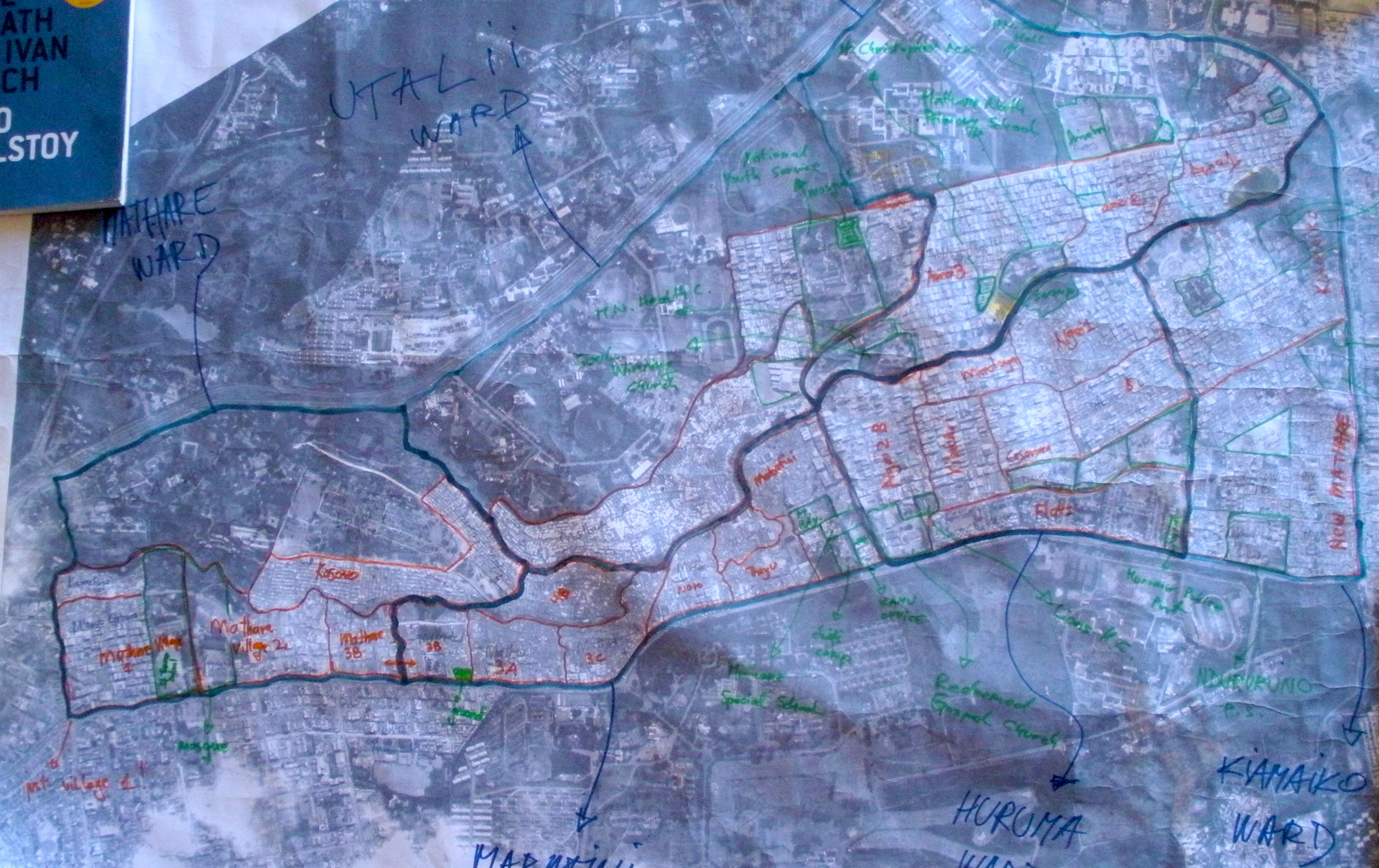
For the purpose of determining the village boundaries we printed out the satellite imagery of Mathare, which was donated to us by the American Association for the Advancement of Science. After that I gave the satellite imagery to Simon Kokoyo form COOPI and Reality Tested Youth Program. He walked around the slum and talked to elders, who helped him determine the village boundaries of the slum by drawing them on the printed satellite imagery.

Drawn village boundaries

Drawn villages of Mathare

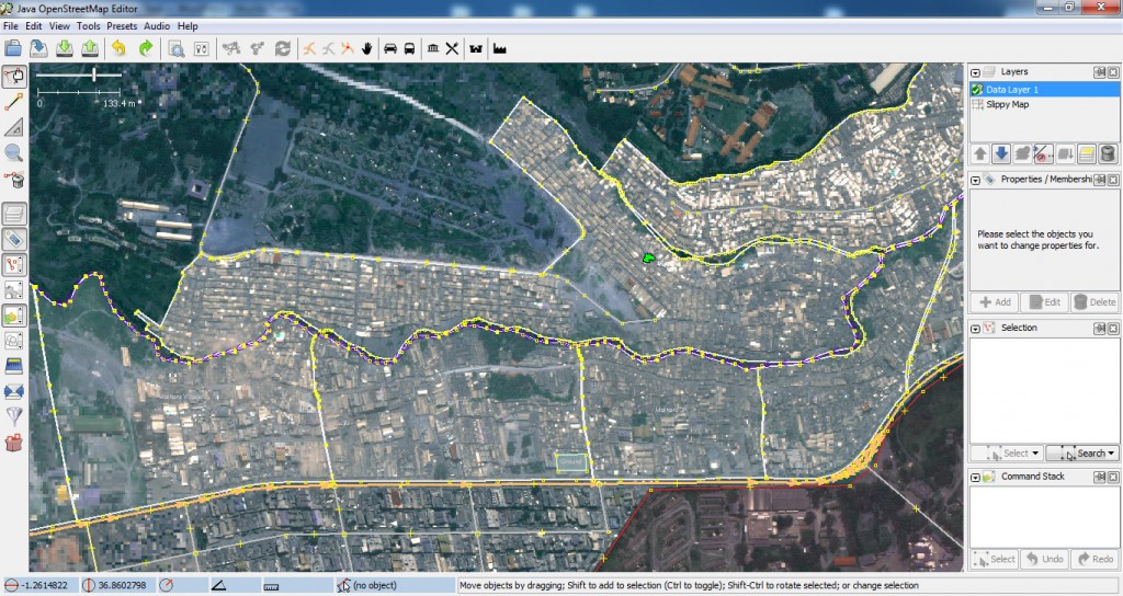
I uploaded the satellite imagery into JOSM and digitized the boundaries according to the drawn image.

Digitizing in Java OpenStreetMap Editor

Digitizing in Java OpenStreetMap Editor

And HERE are the villages of Mathare and Mathare slum area in OpenStreetMap – the borders have already changed couple of times :)

Thinking long-term in Kibera, Mathare approaching quickly

by: November 25th, 2010 comments: 0

To follow up on what Mikel wrote in his post called Map Kibera has become a Research Subject. Happily!, this is the situation on the ground at the moment.

While Mathare is approaching with fierce speed the Kibera teams are working hard to set up the Trust, struggling to create their basic visions and missions, developing their personal goals, thinking of ways to get their work across into the community (something that hasn’t been done yet) and preparing to train others. Working on two fronts is going to be, well let’s say challenging.

But how much excitement and effort can we really expect from our teams to do something we feel is good, maybe even good for them? When asked what their vision, mission and goals are all I hear is the mantra they picked up along the way about how they want to contribute to open data and sharing of information and being the eyes and ears of the community etc. But do they really know and understand what this means or are they just repeating something they were told is good? After all they are going to be the messengers to their communities and based on their messages the communities will react. We say we’re doing this to see how open data can influence the marginalized communities to better advocate upon themselves. But what do they want out of this? I know people have been trying to answer these questions before but it’s somehow different when confronted with faces in front of you, it’s much more personal.

On our meetings I challenge them and ask them what their personal goals are. What do they want and expect from the programs? Do they want to volunteer in these programs forever? What are they doing to distinguish themselves from the thousands (if talking of You Tube millions) of others who are doing the same? When asked this question they usually answer that they want to get paid or get paid jobs, be famous, travel the world etc – these are real dreams, real life goals. And aren’t we doing this so we can empower members of this community to advocate upon themselves and to have a better chance when competing with the luckier and the richer comrades?

Voice of Kibera team

That is why we’re now trying to make them look at what they are doing as a business, a marketing of their skills. They need to sell their ideas and their talent. They have the opportunity to do that through the programs they are involved with. They can still be the eyes and ears of the community and still influence change but they also need to think about the sustainability of the programs which will be achieved only if they are satisfied with what they are doing.

So the discussion in the past week has been how to raise awareness about Map Kibera’s programs while putting the skills and ideas of the three groups on the market.

The Map Kibera teams are planning several activities to achieve this goal:

The Mappers will raise awareness through Atlas distribution. They plan to do this through a publicity gaining “Atlas launch” to which they plan to invite government representatives, NGOs, UN representatives, community leaders etc. They will ask for small contributions which will be used to print more maps. They also want to distribute the Atlas and hold lectures in schools of Kibera, identify public places to post maps, start public discussions regarding the data collected by organizing community meetings, and they even plan to start a discussion regarding naming the streets in Kibera. Last but not least they want to re-do (update) the map.

The video team wants to start weekly public screenings to showcase their talent and present their work to the community and hopefully start discussions around the stories and events they collect.

Voice wants to set up stands and distribute flyers and stickers to publicize the number.

All of them want to train others. It’s serious stuff and hopefully something good comes out of it! And while the Kibera teams are thinking hard about all these issues, Mathare is like a bee hive, full of expectations, ready to go to the moon. The venue for the forum is reserved and people are being invited.

Mathare

The forum will take place on December 1st and will last about half a day. We’ll start with introductions from Rose and Simon (CCS and COOPI). CCS will than facilitate “mapping with the feet” , a participatory exercise that asks participants to place themselves within a room with relation to their geographical position in the community in question, to show the participants what mapping is in the simplest of way. The Kibera teams will then present what they did in Kibera and invite people to the stands where they will showcase the equipment and methods and answer more questions. In the end we will open the stage for discussion.

Anyhow it’ll be interesting couple of months. At the moment there are more questions than answers, but hopefully by the end the tide will shift.

Oh… by the way, Mikel and Erica left. Sorry for us.

Map Kibera has become a Research Subject. Happily!

by: November 24th, 2010 comments: 3

This past month, Map Kibera became a research subject. And it couldn’t have come at a better time.

With all the excitement (or hype) around technology and mapping in development, there has apparently been very little academic or solid web based research into the challenges faced when applying the methodologies of participatory technologies to participatory development and aid (excepting a few highly valued voices like Paul and Linda). Basically, what will make you pull your hair out when trying to bring Open Source to the Whole Wide World? We’ve long recognized our own shortcomings in Map Kibera, and make no effort to hide them, but we have lacked an objective and constructive critical view. It’s so difficult to find critics of our project, that I was contacted to possibly provide the dissenting view to the recent BBC World Service report on Map Kibera based on this blog post!

What especially interested us about working with Evangelia Berdou from IDS and Samuel Musyoki from Plan was that the research was designed to not be extractive, resulting in research papers only for the eyes of academics, but to be immediately practically useful for the program itself. Evangelia and Sammy conducted interviews and focus groups with just about everyone, and wrapped up with a general meeting with representatives from all facets of Map Kibera to present the results together. It’s totally appropriate to call this group therapy! Sammy did a masterful job at drawing out honest reflections on the past year with just a little prompting, and I will be keeping the small trick of passing a literal baton between tight lipped participants to get them to open up. The focus groups were followed up with an incredible 3 day workshop on understanding learning, so that everyone is prepared for training others in Mathare and elsewhere.

One year on. It was the second Monday of November 2009 that we started mapping. Kenyatta Day (now Mashujaa Day) marked our official one year presence in Kenya. It was only supposed to be one month to start, then four months, now one year! Looking back over the past year, honestly so much has been accomplished, it’s staggering. With a small informal and fluctuating initiating team, and eager and motivated young people, Map Kibera has done incredible work and made huge waves. I think we demonstrated that the technology and the training totally work. What we continue to struggle with is everything else! The sticking points are the social and organizational dimensions of the introduction of this technology, but maybe more crucially ourselves as newcomers, to an extremely complicated community with a complicated relationship to the international community.

There’s much to reflect on the topics of Money, Organization, Expectations, Communication, Commitment and more. Each of these deserves at least a post in themselves, and I’ll return to these and others to dig into what we’ve learned about making open source work for development.

This post is part of a series exploring the ideas and issues that have emerged in our research project with Institute of Development Studies, supported by DFID. All posts from the Map Kibera team, the researchers from IDS, our trainers and colleagues are collected here. As always, we are eager to discuss this work, so we hope to hear your comments.