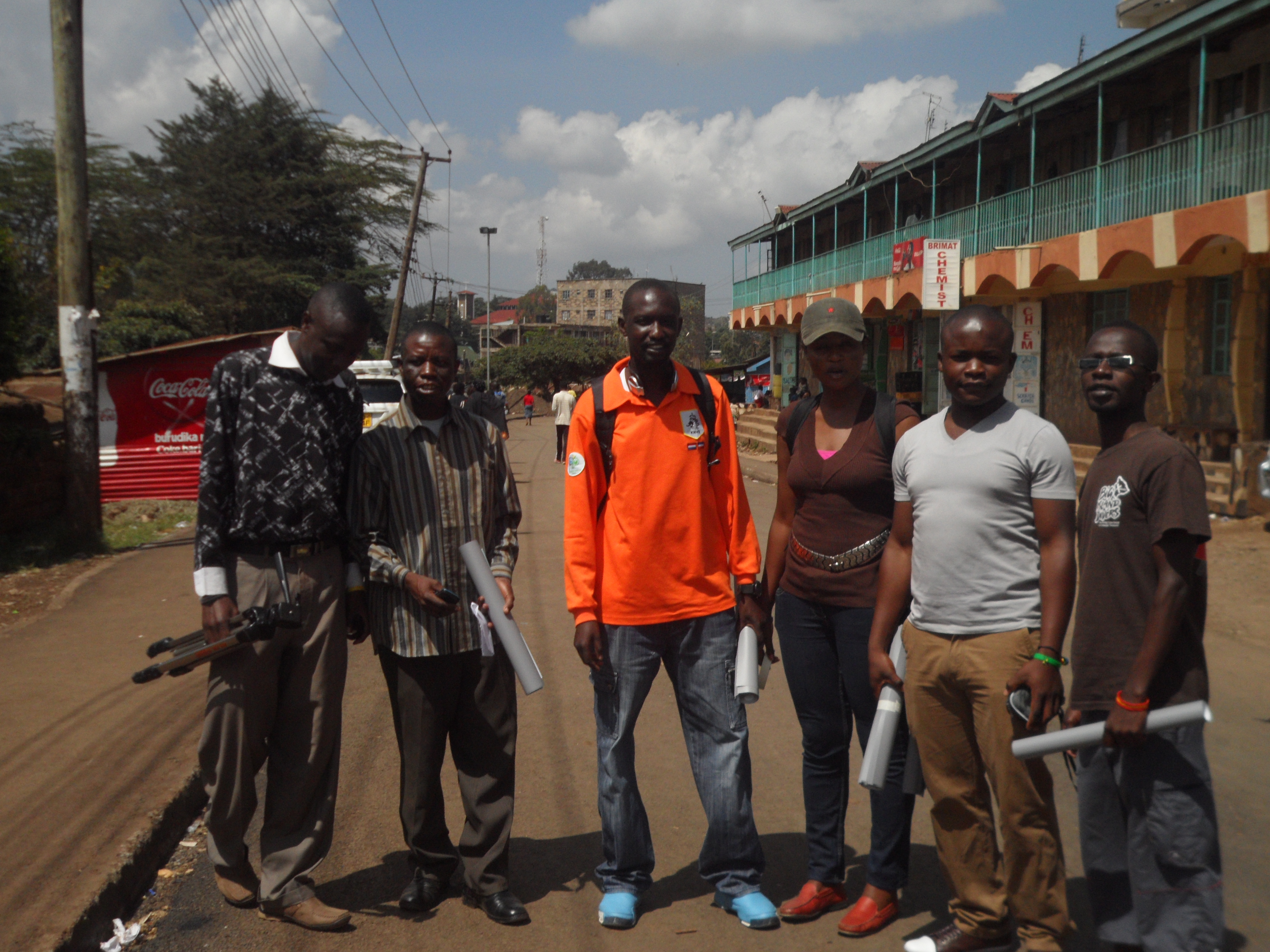
Having been the first organization to put the entire Kibera slums on the world map, Map Kibera Trust; an organization that seeks to be a hub where access to open information contributes to positive community transformation was on the road again to ensure that the maps that were produced reached the community which in-turn would put them to use.
To achieve this, the program coordinators met for the preparation of distributing the maps; there intention of meeting was to bring the attention of the three programs on how they will be working together towards achieving the objective of the exercise and to come up with relevant locations for maps distribution. It was there that they agreed that members from the 3 programs; Mapping, Voice of Kibera and Kibera News Network were to go to the field to distribute the maps which had been developed based on themes. Maps on Education, Security and Health are the themes that were distributed.
The aim of the exercise was to give back to the community through the high quality printed maps that contain the informational that came from them during the first phase of the mapping exercise.
Villages covered.
For the 2 days that we were in the field, we were able to cover all the 13 villages; Gatwikera, Raila, Olympic, Soweto west&east, Kianda, Kambi muru, Kisumu ndogo, Lindi, Mashimoni, Makina, Silanga, and Laini Saba.  Â
Positive Feedback From the Field.
As we visited different places, we collected feedback from the people we found so that we could ascertain how the maps will be put to good used.
The local administration appreciated our work and accepted to be interviewed i.e. Sarang’ombe and Laina Saba ward chiefs.
Most of the institutions accepted to use the map for positive transfiguration most of the institution wanted more than one map so they can use it for informational purposes as well as Education especially the Schools we visited.
We even had a chance to meet with D.O 1 (District Commissioner) who had a compliment for us saying that our map was outstanding compared to the one they had before.
For those who were not able to access our maps online were able to access them on hard-copy something that was important for us since it was now realized.
We ensured equal distribution of maps in at least all villages in Kibera.
Some of the Challenges.
Though most of the places we went to were very receptive, we experienced some hostility in a few areas where we were thought to be a different group out to just take advantage of the situations in Kibera by walking around to talk to people as we take photos to go and sell. After a few minutes of sharing our intentions with them, they understood us and we gave out the maps, something they congratulated us for showing a good example to organizations by sharing the findings of the work done with the community. We also found some schools that were to get maps already closed for holiday which means we will have to give them the maps when they resume school.
Conclusion.
In general, the exercise was a success only for the schools that had already closed. Going forward, we need to print big and more visible maps a suggestion that came from one of the places we visited.
We hope that the maps distributed will not only be put to good use but also help Map Kibera Trust bond more with the community so that even as we get ready to cover the vents before, during and after the elections, we can work together to achieve optimum results and that Kibera and the other slums we are currently working with (Mathare and Mukuru) will never be the same again.
and if you’re curious, a little more detailed Report
Kepha Ngito is Executive Director of Map Kibera Trust. This post is his first in a series of personal reflections on his experiences with Map Kibera.
The Accra effect
Recently I attended the ON (Omidyar Network) -Baraza together with the African Leadership Network conference in Accra, Ghana. Both events happened one after the other at the same venue, the Movenpick Hotel. Irony is that I found peace of mind to write down these thoughts while in a 5-star hotel in Accra, Ghana, and not in a tin, stick and mud shack in the heart of Kibera, Mathare or Mukuru slums in Nairobi. These last 3 locations are normally my dwelling places, not just physical dwellings but psychological dwellings and lately, professional dwellings. I was only a visitor in Ghana, a country with a lot of history.
Being in Ghana or say, the comforts of the hotel ironically provided a certain ‘peace’ of mind and quiet – a rare luxury for most people living in slums — that enabled me to reflect enough to write this article. Even though I don’t compare myself to those in prison or exile, I understood why they write better and longer articles.
For nearly 10 months now, I have been working as the Executive Director at Map Kibera Trust. I am also one of the founding Trustees of the organization. A quick attention grabber would be that we worked with the community to make the first digital map of Kibera and ‘placed’ it on the Kenyan map after decades of its depiction as a forest on the country’s official map. We have since done the same for Mathare and Mukuru.
With a team of about 45 people (15 in each location), we are a group of people who believe that mapping is the first step to affirming that a people exist somewhere, even when they have been pushed to the periphery of mainstream development and tagged as ‘informal’ or depicted as a forest, a quarry site, a swamp, an electricity reserve or a garbage dump site in official maps. For many years, over 60% of Nairobi residents who reside in the many slums in and around the city have occupied the ‘non –formal’ residential areas and built what is now known as ‘informal settlements.’ Putting them on the map physically, then socially, then economically and even politically by encouraging an information-driven culture of advocacy is what we have been working at in the last 2 and half years of our existence. In this way, we attempt to ‘formalize the informal’. It’s a pity that some people’s identities are carved for them by others and by circumstances beyond their control. Where we live or lived does not necessarily make us who we are. We believe that we are not products of our environment, we are the creators of it, we sustain its beauty or unbeauty and that’s why we must be the people to change what’s wrong about it.
‘Development’ chaos in the slums
Even as I waited eagerly to interact with other invited leaders from different parts of Africa and the world at the Accra conference, I couldn’t help but reflect at the journey we have made in Kibera, Mathare and now in Mukuru. This was a journey aimed at increasing the spaces of transparency, establishing credible information and data and making it open and accessible to people. Offering marginalized residents alternative citizen platforms to voice their own stories (see Kibera News Networkor Voice of Kibera), making maps, updating them regularly and teaching people how to use them to discuss development issues at community level. Slums are like oceans with many things that cannot be discovered at a glance.
For many years, NGOs and organizations with good intentions swarmed into the slums each armed with a silver bullet – a philosophy that they strongly believed in. These projects were usually too brief to make any meaningful or sustainable effects in the community. They also had very fine points of focus with very strict statistical deliverables and timelines mostly targeting large amounts of quantitative data as the main outputs. As a result, beyond the beautiful statistics, published project reports and nice photos shared among their elite donors and ‘partners’, nothing much of substance came to or remained with the people when these projects came to an end. (Usually they tended to leave as soon as the project money ran out). This ‘development chaos’ characterized by competition for space, donor funds and the community’s goodwill led to the loss of professional integrity, lack of consistency and loss of the urge to network among like-minded initiatives. Corruption found a breeding ground and boom!, a ‘virtual slum’ was created, a slum made famous for the wrong reasons and constructed by NGOs and aid organizations whose ideas have failed to build the community and who have created idle structures that stand in the way of and frustrate new practical methods, ideas or development. And while all this is happening, the real slums and their challenges remain in the shadows wallowing in ignorance, poverty, disease and crime, and watch every day as a new truck passes by full of visiting ‘partners’. The mama mboga sits at the same roadside mud kiosk every day and barely manages to turn away her face to avoid the camera flash glare. She probably wonders why some people are so interested in her picture. She can only complain by turning her head away.
The approaches to paper mapping are well described by Mikel in his blog post called Paper Mapping in Community Meetings. What I would like to add to his points are the reasons why we conducted the paper mapping in the first place. To name a few:
Feedback. To acquire feedback from the wider community regarding the maps and the data collected by a few community members.
Understanding the place. To understand the areas where we are mapping – more accurately, to at least trying to understand complex places like Kibera. Outsiders to communities often overlook this step, and end up conducting projects in communities that they don’t really understand and haven’t taken the time to learn much about.
Acquire more information. We wanted to collect more information and double-check the information collected, find the missing objects, listen to the stories regarding particular issues, and to identify specific problems and solutions to these problems.
Monitoring the accuracy of the mapping. Through community’s input we were able to monitor the accuracy of our mapping endeavor.
These were the reasons I decided I’m going to look closely into these paper/drawn maps and try to understand what the people from Kibera were telling us. I’ve done a similar exercise before with Joshua Goldstein (as a part of Map Kibera) who was at that time working for UNICEF Innovations. We – together with the rest of the Map Kibera team, of course – had created the first, and the most comprehensive Security map of Kibera. Now it was time to focus on other problematic areas, where we also involved community members who drew on our existing map to add information and new issues. For that reason, there were, and still are, some twenty or so drawn, paper maps stored safely away in cyberspace, which cover issue topics ranging from education, health, water and sanitation. To extract useful information from these maps required some Photoshop magic. The first maps I looked into were the water and sanitation maps.
So what did we ask, and what did the community tell us?
Identifying missing resources:
Is it representative?Is anything missing or mislabeled?†were some of the questions we asked to help us see the extent of the missing data. The feedback made us realize that we missed a lot, and it made us realize we need to re-do the mapping.
Missing
Identifying problem areas:
What and where are the biggest problems regarding water and sanitation in the community? Which water points and toilets would you say are the worst and why? Are there many people who use public spaces for toilets?†were the questions which helped us identify the most pressing issues and problems. Some of the major problems identified were:
Major problems/issues
All streams are used as toilets and dumping sites
There is a health hazard because the people at times use the railway as a toilet, garbage dump & a cooking point
Misuse of the drainage system as a dumping site
Stories behind issues:
What would you say are the largest and most direct challenges to providing quality water and sanitation? What is the biggest need regarding water, waste disposal, and sanitation in Kibera? What would you want the Government and other decision makers to know about water, waste disposal, and sanitation in Kibera?†These questions helped us collect stories that lent insight into the complex dynamics of Kibera. Some stories:
Stories connected to water and sanitation
Different amounts of money is required depending on which toilet you use
Solid waste management is poor
Vigilante groups demand money for the toilets which are to be constructed in their area
Maintenance of toilets is a big problem; toilets get polluted quickly
For “short calls†people use plastic tins; flying toilets (plastic bags in which people defecate and then throw out of their home) are used at night because of insecurity
Households use paper bags for waste collection; these bags are then picked up by individuals and groups who bring them to collection points for a certain amount
Mapping mobility:
Where do your collect water? Where do you use the toilet? Where do you dump trash? Why?†By asking these questions we were able to observe the movements connected to the water and sanitation. Some of the findings that came out of the mobility mapping were that:
Mobility connected to water and sanitation
People dump their trash into rivers, and the rivers serve as collectors of most of the garbage from the slums
There are some points of data collection within the slum where the city council collects the trash and transports it out of the slum
People don’t necessarily use the closest toilets and water points but look for the most affordable ones
Solutions:
How would you solve some of the problems you pointed out? In what ways can you envision using this map to improve water, waste disposal, and sanitation in Kibera?†These questions encouraged people to share their views on how to solve certain problems regarding water and sanitation:
Some of the solutions
Awareness and education
Need for weekly garbage collection
More dumping sites, more toilets to be constructed
Stakeholder involvement – coordination between stakeholders
Partnership involvement – CBOs, NGOs, and landlords should come on board to make sure that each plot has a sanitary facility/usable toilet
Paper mapping or drawing exercises proved to be a very useful feedback mechanism and also a very useful tool for planning. The community’s knowledge is priceless and only the community understands and knows all the answers. There’s no point in figuring out something new when the solutions are already available and when all you have to do is just listen!
Before the late 1980s and early 1990s when some of us were so excited at what we were finding local people could do, much indigenous, local and participatory mapping had already taken place in different regions, countries and continents. Mapping and various forms of spatial representation by local people on their own have a long history, and very likely a prehistory!
More remarkable than what local people had already done in mapping and other forms of spatial representation was “our†educated professional ignorance of their mapping abilities.