Just yesterday, I imported the Map Kibera data into OpenStreetMap. I thought I’d take the opportunity to review how the data collection went in this entirely unique process, allude to a few of the mind-changing map features of Kibera that I’ve yet to fully comprehend, and provide some guidelines for further data clean up. I’ve been spending spare time over the last few weeks in Chicago working on the data, but realize this needs the help and energy of the entire community. If you’re interested to help, please get in touch.
In short, a pretty map geeky post! Divided into ways and nodes. This may excite you, or not ;)
Ways
Ways in Kibera encompass roads, paths, streams, sewer lines (sometimes hard to tell the difference between those two), village boundaries, the railroad line, walls, permanent buildings (there are many, yes), open grounds/playing fields, and markets. So far. An incredibly dense, informal area, there is a challenge to the uninitiated to simply decide what constitutes a public road in Kibera. As it turns out, Kibera has a complex structure well known to its residents. Collecting these ways required a combination of GPS surveying, which worked reasonably well even in a dense area of corrugated iron roofs, and satellite imagery, notes written on Walking Papers and in conversation. Both introduce their own accuracies and inaccuracies, so there’s also an element of artistry involved, as usual with cartography.

These were initially traced by [User:Harry Wood|Harry Wood], from purchased DigitalGlobe satellite imagery collected in February 2009. Harry did a phenomenal job locating paths in this new terrain, which for the most part were later verified by GPS tracks. During and after the surveying phase, myself and other mappers traced from GPS tracklogs uploaded to the Map Kibera site, and from higher resolution GeoEye satellite imagery collected in July 2009 arranged by Lars Bromley of the [http://shr.aaas.org/geotech/ AAAS Geospatial Technologies and Human Rights program]. The GeoEye imagery was higher resolution (50cm, vs 60 cm for DG), brighter with a better color balance, but didn’t match the rectification of the February imagery, or of the GPS tracks. What followed was a series of tweaks and feedback between a very patient Lars and myself of re-rectifying the imagery; we finally got something which matched the GPS tracks more or less, and both learned that satellite imagery has shades of accuracy, subject to shakes in orbit, different angles of acquisition and lighting, that mean any correction in one direction results in a mistake in another region.
Besides the July imagery, the AAAS very generously donated purchase of another 5 satellite images from over the past three years in Kibera. We are very eager to explore the possibilities of automated and manual change detection and story telling using this resource; Kibera, like slums everywhere, changes rapidly, due to improvements by residents, resettlement by the government, acquisition and construction on private plots (mostly churches), and conflict on small and large scale. Imagery will help inform our understanding of these dynamics. For the moement, we have simply posted the layers to [http://aerial.maps.jsintl.org/layers/], and you are free to browse and select a slice of time. Particularly interesting are the Toi Market area, completely destroyed in the post-election violence and re-built in a new planned model, and the east side of Soweto East, the site of the first relocations and road construction. From these images is possible to date the Google imagery over Nairobi as pre-2006. For mappers, there are still a few permanent structures and walls that could use more tracing .. get in touch, and I can give you the JOSM or Potlatch settings for using the imagery.

Nearly all traced paths in OSM had GPS tracks associated, but not all, and in very dense areas, some artistic judgment was required to trace where a narrow path might really be going (these can of course be improved as more data is collected by other mappers). Road classification is still a challenge. In the formal villages, Olympic, Karanja, and Ayani, the roads are wide enough for vehicles, unpaved or in bad enough repair to qualify as unpaved, and very clearly evident in satellite and GPS, so highway=unclassfied or highway=residential. In the rest of Kibera, the situation is more interesting; for a place with no official centralized planning, there has definitely evolved a hierarchy of roads, branching fractal patterns intimately influenced by Kibera’s rugged topography. Some are wider, full of commerce, and obvious “main” roads; these have been tagged as highway=track. There are narrower paths, that are still very “public”, with significant commerce and foot traffic. These have been tagged as highway=footway. Also tagged as highway=footway are public paths through primarily residential areas. There are also even more narrow paths, nothing more than spaces between buildings, but still public; and paths that are practically private, through private plots. These all need differentiation, possibly though use of abutters=residential/commercial and private=yes tags. Complicating matters, the railway is the main thoroughfare of the area, so should be also indicated as a pedestrian area, and many of the creeks/sewers sometimes serve similar functions.
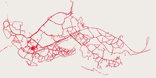
The village boundaries were initially roughly drawn from a [http://warper.geothings.net/maps/1640 map commissioned by Carolina for Kibera 7 years ago]. These were tweaked by mappers physically walking village boundaries when possible. Often these boundaries follow streams/sewers, or particular roads, and everyone is aware of precisely where they lie.
Nodes
Points of interest were the primary survey and editing activity of the Map Kibera mappers. They marked waypoints on the Garmin eTrex Legend HCx GPS, and made marks and notes on Walking Papers. They very quickly got hang of this, though there were particular subtleties, and sometimes not so subtleties, which we are still working to master.
One error that crept up occasionally were waypoints placed in an location different from where the mapper was standing. This occurs when the joystick on the GPS was moved, and quickly depressed, which the units interprets as intentionally placing a point in a different spot; vs holding the button down for 2 seconds to mark the present location. I have to say, that joystick is too clever, a persistent usability problem that has a steep body learning curve, especially for people who haven’t grown up with game controllers. Most of these errors were picked up immediately and resurveyed later; they were obviously misplaced, either in absurd locations or mappers in the wrong village, but certainly there is possibility that a few slipped through.
Each mapper definitely had their own style. In the intense density of Kibera, selecting which features are “important” is a judgment call and a matter of interest. There’s a baseline of water and sanitation features, clinics, religious and community buildings, etc. Some folks found m-pesa points important to collect, others not. Some folks picked every water collection point or water tank, even if private. Both of these things still need consistent, new tagging. Features like posho mills, battery charging stations .. entirely non-existent on any other maps. Is a movie theater in Kibera a movie theater, when it consists of a small dark room, a TV, and a DVD playing pirated movies? How to tag a witch doctor’s clinic, which these days are called “herbalists”? Most of the details on all these new features are simply in the NOTE or even name tag, all POI need some review.
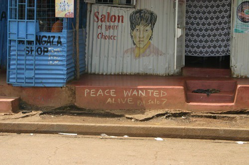
Caution is needed. Even a name may not be a name. The use of a structure changes more rapidly than the availability of money to repaint a sign. So the sign might show a beauty parlor, but it’s currently used as a tailor, and everyone knows that and calls it by it’s “spoken name”. How can the map reflect both what residents already know, and what an outsider might need to know to navigate.
Some villages have much higher density of collection … as some places do have higher density of commerce, while others may be primarily residential, due to their placement peripherally to Kibera. Some are quite small, like Soweto West, so possible to comprehensively collect all. Others large places, like Makina, required additional surveyors in addition to the primary mapper, and it shows — occasionally I saw duplicate features. Capitalization never seemed to sink in with everyone … they just don’t use computers enough to care. Also, there was little care for which side of the “road” a feature sat on … something we can also improve with error checking days.
The density of features is really going to require moving to abutters and ways for many commercial areas. For web interfaces, we’ll need to separate things out into thematic, toggle-able layers. For print, we’re going to do a series of maps, atlas style, each focus on a different theme, with more narrative and photos.
So
Chickens, goats, dogs, movie theaters, hardware stores, pubs, kerosene, charging stations, butchers, trees, sewers, rocks, mud
This is quite interesting and useful. I expect the process that you are discovering is going to be similar to the real mapping process for a lot of the world.
I will point some folks in India to this post. They are working on similar problems for a large set of communities.
Thanks David. We are very interested to see how the model of Map Kibera could apply in India. Please let us know who we should be talking to.
I just learned about this project from Flickr’s blog. This is incredibly exciting work.