When around 15 police trucks came to Kibera a few weeks ago to witness and protect the demolition of schools along the railway line, there was shock and tension as Spurgeons school was targeted. But before the bulldozer could reach the permanent building, the community members turned up in large numbers to stop the demolition, saying that the school belonged to them. They claimed that the school has been helping their needy children and they could not sit back and watch it go down.
“Bars are operating you can hear loud music, but schools that are helping the children are being demolished, what’s the government doing?â€
47 schools, along with other structures including churches are expected to be demolished during the project, but attention to St. Juliet and Spurgeon forced a halt on the process for a while.
Kenya Railways decided several years ago to expand the railway buffer and reclaim the land, citing safety and interference with train passage. In 2010 they made their most recent enumeration of the residents and businesses along the track targeted for demolition, but residents say that these are already outdated. While residents have been promised new housing, they do not appear to have made concessions for the schools operating in the buffer area, other than saying that the schools be shut down and students enrolled at nearby government schools.
Recently, a petition by a section of the Project Affected Persons (PAPs) had been filed in court and a ruling was made, stating:
1. The petitioner’s petition fails and is dismissed
2. The Respondent’s cross-petition succeeds and it is hereby ordered that the recent illegal occupiers of the Railway Reserve whose names do not appear in the list of the Project Affected Persons do move out of the Railway Reserve and allow the Corporation to proceed with the Resettlement plan.
Their evictions however will have to take into account the following factors:
That at the time of eviction, neutral observers should be allowed to access to the suit properties to ensure compliance with international human rights principles.
That there must be a mandatory presence of Government officials and security officers.
That there must be compliance with the right to human dignity, life and security of the evictees.
That the evictions must not take place at night, in bad weather, during festivals or holidays, prior to any elections, during or just prior to school exams and in fact preferably at the end of the school term or holidays.
That no one is subjected to indiscriminate attacks.
The PAPs had demanded in their petition that a review of the enumeration be done since a lot of things had changed since 2010 when the last enumeration was done, but the Kenya Railways refused saying that it was going to be a waste of money and time and would only add more complications to the plan.
Community Meeting with Langata Youth Network
Recently, Langata Youths Network organized a forum to bring together all the affected schools and churches along the Railway to look at the way forward. They resolved that the people concerned with the demolitions be engaged further to make them understand why dialogue was still important in every stage and step they make. They also said that they will try to respect the court ruling by all means, but they wanted to understand who made the decision that some schools to remain while others to be demolished. The group then formed a committee to help follow up with all the relevant offices.
There has been a lot of silence since the demolition of the few schools happened, until recently when we saw a notice posted asking the PAPs to go for a vetting process. This sounded to me like a review that they had all along been crying for only called by a different name or word. It says that the vetting and complaint lodges will continue and a final list of the PAPs would be published publicly.
Meanwhile the schools already demolished are proceeding with learning as best they can. St Juliet returned some of its class roofs, while Spurgeon is squeezing inside their permanent building that the community members had narrowly rescued in the presence of heavily armed police.
According to the Relocation Action Plan (RAP) Document the Schools along the railway should close down and send their students to the few public schools in Kibra, but the Schools wondered how they would do it since the RAP did not give a proper guideline on who is responsible for taking the students to those particular public schools, and were not sure whether they would be admitted.
This piece was a collaborative report by Map Kibera’s team as part of the Open Schools Kenya project. Reported by Joshua Ogure, with map by Zacharia Wambua, school locations by Lucy Fondo and Douglas Namale, and reporting from Steve Banner and Jacob Ouma.
The following article is by Professor Bitange Ndemo, former Permanent Secretary of Information and Communications, Kenya, who was largely responsible for Kenya Open Data‘s emergence in 2011. He is currently an Associate Professor at the University of Nairobi Business School. We were honored to have him in attendance at the launch of Open Schools Kenya in Nairobi on February 24. Following the event, Prof. Ndemo published this column in the Daily Nation newspaper, republished with permission:
Speaking Truth and Unveiling Opportunity: How Map Kibera Brought Hard Facts to Bear
In the past week, I attended three unrelated conferences. If they had been mashed together, a ground-breaking innovation would have emerged.
The first meeting on Monday morning was the launch of school data by Map Kibera, an initiative to map Kibra (formerly known as Kibera) and make it easier for residents to locate social services.Â
On Wednesday morning, I chaired a session at a regional conference of postal organisations trying to find ways to cope with technology and save themselves from extinction. One of their needs is a postal address system to start home delivery of parcels in the growing e-commerce industry.Â
On Thursday afternoon I was giving a keynote speech to creative artists trying to find their role in the emerging digital space. Had we combined these conferences, the outcome would have been a better solution to the problems facing our country.
It emerged that all the three conferences needed a great deal of data if they were to succeed.
In Kibra, data was essential in engaging policymakers with hard facts. For example, data from the mapping shows that primary operators for Kibra schools include NGOs or CBOs at 37 per cent, private owners at 29 per cent, religious organisations at 27 per cent and government at 4 per cent.Â
So when the policy statement of the Education ministry on Form One admissions is biased towards government schools, they should understand who they hurt most.
Postal corporations need data on trade and movement of goods for better logistical planning. They also need ways of reaching customers wherever they are.Â
Finally, creative artists need data on media and entertainment consumption patterns as a basis for developing new business models and meeting customer demands. Â Â Â
Whilst Map Kibera has the perfect solution for Posta to reach people they have never reached before, Posta is hedging its bet on a policy process to allow them reach the unreachable.
TOILET-TO-PEOPLE RATIO
Let me confess that I started the process of street numbering with the hope of using Global Positioning System (GPS) in informal settlements. However, bureaucracy took many turns and by the time I was leaving, we had only covered the Central Business District (CBD).Â
My thinking was to create addresses for the entire country first, then create a law. However, that has changed. The law will be created first, before we create the addressing system. Innovation in my view precedes legislation.
Meanwhile, residents of Kibra and other marginalised areas are being taken advantage of by unscrupulous people. “They are stealing from the poor,†area MP Kenneth Okoth says.Â
The MP was particularly livid with Nicholas Kristof and Sheryl WuDunn’s latest book, A Path Appears: Transforming Lives, Creating Opportunity, in which he says numbers had been exaggerated to portray Kibra negatively.
The MP wondered what logic Kristof, a New York Times columnist, two-time Pulitzer Prize winner and co-author, used in stating that Kibra had a toilet-to-people ratio of 1:1,300.
The MP rightfully said that if that were to true, given that the entire day has 1,440 minutes, then every morning you would see queues of people waiting for their turn in the toilet, that they must use it very quickly indeed to enable others to use it.
Curiosity forced me to buy the book. It reads like a global green party manifesto, profiling social-justice individuals and groups, and describing concerns that range from environmental issues such as clean energy and reduction of deforestation to social issues such as battling foetal alcohol syndrome, sex trafficking, malaria, clubfoot, cleft palate, sexual assault against children and women, Aids, lack of potable water, illiteracy, child malnutrition and poverty.Â
OPEN DATA, OPEN SOURCE, OPEN ACCESS
In Kibra, they profile my friends, Kenneth Odede and Jessica Posner. Like many people before the census data came out to confirm the Kibra population, Kristof was largely relying on guesswork that later could be mistaken for exaggeration.
Anyone reading the book could perhaps criticise Kristof and WuDunn for neglecting to mention some of the prominent NGOs working to mitigate these maladies. They also fail to bring out the impact of climate change.Â
However, Mr Okoth and the co-authors Kristof and WuDunn agree that some of the resources meant for the poor get stolen. Indeed, if every shilling raised to alleviate poverty in Kibra were to be used for its intended purpose, every one of the close to 400,000 residents will be on a comfortable monthly salary for at least five years.
According to the Bible, God prohibited such theft in Proverbs 22:22-23 (KJV): “Rob not the poor, because he is poor: Neither oppress the afflicted in the gate. For the Lord will plead their cause and spoil the soul of those that spoiled them.”
But before God makes the sinners repay, we can prevent this through building open data platforms like Map Kibera.
Before I tell you more about what Map Kibera is and how it converges with Posta and the creative economy industry, let me first explain the concept of open data because it cuts across the interests of these three groups.Â
Open data is the idea that certain data should be freely available to everyone to use without any mechanisms of control. For example, information on who is providing social services to the poor, who funds such activities and how much is funded, should be in the public domain.Â
The goals of the open data movement are similar to those of other “open” movements such as open source and open access. It is critically important for stakeholders to know how much of the money raised for Kibra comes to Kibra.Â
Residents can also ask the right questions, for example, how much Constituency Development Fund (CDF) their MP received, and where it was spent.
PARCELS TO ‘UNREACHABLE PLACES’
Map Kibera was officially launched at Eastlands Hotel on Tuesday last week. The low-key event was witnessed by the area MP, Ken Okoth, Nairobi County Education Minister Christopher Khaemba, Erica Hagen of Groundtruth and many other dignitaries from Kibra. Â
The project originated with a winning entry to the Gates Foundation Grand Challenge pilot contest on data interoperability, early last year. Map Kibera was a key entrant with partners that included GroundTruth Initiative and Development Gateway. Â
Ms Hagen co-founded Map Kibera Trust in 2009 with her partner and a team of youths in Kibera, several of whom are still part of the Trust and worked on this project. GroundTruth Initiative was founded in 2010, also by Ms Hagen and partner Mikel Maron. Â
Hagen and Maron live in Washington, DC, and work through GroundTruth (a small consulting firm) to spread more globally the kinds of projects that Map Kibera has become known for, such as citizen-led mapping, data, journalism, etc. They also remain quite involved with Map Kibera itself.
We can now locate assets in Kibra through the generosity of the Gates Foundation and two dedicated Americans. It is incumbent upon us to make the project sustainable.Â
A private-public partnership with Posta could leverage this project to develop new businesses, while at the same time meeting postal objectives of universal service connectivity coverage.Â
Many of the youths in Kibra can become delivery agents using GPS to take mail and parcels to unreachable places. In similar fashion, the creative society could reach the poor and begin to tell their story through film and bring their plight to the sitting rooms of the rich as well as policy makers. It is an opportunity for the creative to locate the raw talent that lies in Kibra.
Many people like Kristof and WuDunn mean well when they highlight the problems of the poor and vulnerable. We must understand the dynamics of bad reporting on our status.Â
HIDING OUR FUTURE
We are partly to blame when we hide data from the public. There is nothing wrong in telling the world the number of the poor in our midst.Â
Data is the lifeblood of innovation. We curtail our own creativity and progress when we hide data. Data helps us shape policy to respond to human needs.Â
It is such an irreplaceable resource that in hiding it, we would be hiding our future from the pricking eyes of those coming after us.
I submit that Kibra is a problem that presents us with the opportunity to innovate and be part of a global solution in poverty reduction. In bringing together different players such as the ongoing National Youth Project on cleaning up Kibra and not just Posta and the creative sector, we shall be getting closer to a better solution to poverty reduction.
Henry Ford once said, “Coming together is a beginning; keeping together is progress; working together is success.â€
“If you play your part, and you play it to your level best, then your gift will surely open more doors for you,” observed one Fred Ogutu, Hope Academy director.
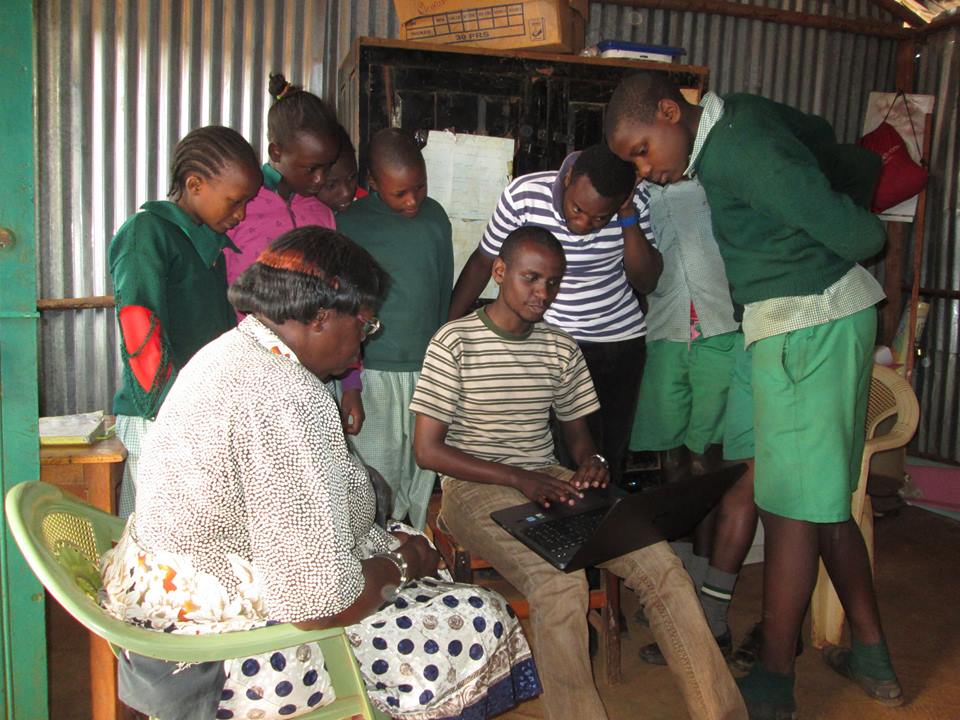
St. Stephene school students and teachers view their school profile online.
We started our distribution on the Langata constituency part of Kibera, that is Raila village. Kibera is spread over two constituencies, Kibra and Langata constituencies, with Kibra having the biggest portion.
All the schools in Raila village had a very positive approach to the map, and the site. They very much welcomed it despite the fact that some of them were a bit reluctant to give out information during the previous data collection.
Map Kibera member Zack Wambua shares the map with Maono Secondary School
Joy and excitement may have sent the Maono Secondary School head teacher the religious lecturer way, telling us that these are the end times and why everyone needs to repent and get ready to receive Christ when he comes. He did that for a few minutes then went ahead to tell us how the school will now use the Open Schools website as their official website.
At St. Stephene school, the head teacher even offered us a job, to help her draft the 2015 school activity plan that she intended to send to her donors together with a link to their page in the Open Schools Kenya website.
Hope Academy school director, Mr. Fred Ogutu, having featured in almost all our previous Project phases including the pre-project survey, was now well informed about what we are doing and congratulated us a lot on the good work done so far. He had a lengthy talk with us telling us that Kibera is a slum that has so much been misrepresented, with a lot of false data out there, he cited an example of the current Government-driven National Youth Service project which has, to use his own words, been blown out of proportion yet none of the clinics and toilets that the government seems to boast about are functional.
He observed that our data is one of the few genuine ones and wondered if the work we do also translate to helping us personally besides fighting to change our community. ‘Are you able to put food on the table and pay your rents?’ he posed a question.
In other villages, that is Katwekera, Kisumu Ndogo, Kambi Muru and Makina, the reception was equally good. We did manage to take fresh photos for FPFK Gatwekera school .
At Joseph Kangethe School, which is one of the two public schools that my colleague Zack and I were assigned to, had a very nice view of the map, The deputy head teacher asked us to come up with forums to educate parents in Kibera on the need to take their children to public schools. She said, contrary to what most parents expressed in the pre-survey, that public schools are being deserted and parents are flooding the non-government schools leaving the government schools with empty classes. “Public schools that had four streams per class have now reduced to three streams. We’ve been forced to turn the extra classrooms to stores because there are no children.”
She also added that learning in public schools is far much better than private schools where children are ‘just drilled and not taught’.
‘What is the government doing about that? And what are you as Map Kibera, in your education project doing about that?’ were her last questions.